 2021, Vol. 38


2. 北京市北运河管理处, 北京 101100
2. Beijing North Canal Management Division, Beijing 101100, China
硝酸盐是河流中氮的主要存在形态,约占河流溶解性无机氮的80%[1-2]。近几十年来,密集的人类活动导致河流中硝酸盐污染严重。这不仅会对水生生态系统造成严重影响,引起河流富营养化和有害藻华[3],而且人体饮用硝酸盐污染的水会增加患高铁血红蛋白、胃癌和甲状腺癌风险[4]。因此,为控制河流中硝酸盐污染,对硝酸盐溯源至关重要。
目前应用于硝酸盐溯源的方法很多,因硝酸盐具有稳定的同位素(如δ15N-NO3和δ18O-NO3)组成,其来源和地球生物化学过程具有差异,因而不同来源的硝酸盐会有不同的同位素组成[5],利用这一特点可以识别硝酸盐的来源。自20世纪70年代开始运用稳定同位素溯源以来,共经历了三个阶段:单一同位素、双同位素和多同位素溯源技术[5]。由于土壤氮源和大气沉降源的硝酸盐δ15N-NO3值相互重叠[6],分别为2‰~8‰和-15‰~15‰[7],单一氮同位素无法对其进行区分。但土壤氮源和大气沉降源δ18O-NO3特征值范围界限分明,分别为-15‰~15‰和23‰~80‰。因此双同位素示踪技术可根据其不同的δ15N-NO3和δ18O-NO3值划分为粪便和污水源(Manure and sewage,M & S)、氮肥源(NO3-/NH4+ fertilizer,NF)、土壤氮源(Soil nitrogen,SON)和大气沉降源(Atmospheric deposition,AP)[9],并可以结合SIAR模型[10]、IsoSource模型[11]确定各来源的贡献,是目前有效判别硝酸盐来源的有效方法。
双同位素示踪技术为研究者追溯硝酸盐来源提供了依据,根据前期调研,目前多数研究都在研究范围内的流域中进行,故其溯源结果仅能代表特定的流域。但气候变化会导致水文状况改变,这使旱季、雨季硝酸盐溯源结果在不同流域有所差别。有关各来源的贡献研究,目前不同流域的旱、雨季结果不一致甚至相反。此外,不同土地利用类型区域的人类行为活动和地表景观不同,导致不同土地利用类型流域硝酸盐污染程度和主要来源有所差异。即使在土地利用类型相似且均为城市的流域,各来源的贡献也有差别。但人们对硝酸盐来源的认识局限在特定流域,对于旱季、雨季我国河流硝酸盐来源的差异以及不同土地利用类型下硝酸盐来源的差异尚不清楚。而整合分析方法作为定量统计分析工具,可通过整合关注同一问题所有研究,剖析研究间的差异特征,得到综合性分析结果。
本研究通过搜集国内外学术刊物上发表的有关我国河流中硝酸盐浓度和来源的文献,并采用整合分析的手段定性、定量评估我国不同土地利用类型区域河流中无机氮浓度和硝酸盐来源的差异。
1 材料与方法 1.1 文献来源在Web of Science和中国知网中检索,检索时间为1980年至2020年6月,英文和中文关键词分别为“isotope”“nitrate”“source”“river”和“硝酸盐”“同位素”“源解析”,并对检索结果进行筛选。筛选标准:①研究领域为中国河流;②研究时间必须可区分雨季和旱季;③必须可提供流域内各采样点的浓度值。通过关键词共检索到英文文献688篇、中文文献335篇,通过上述筛选标准共获得38篇文献,其中33篇英文文献,5篇中文文献,共42个流域。
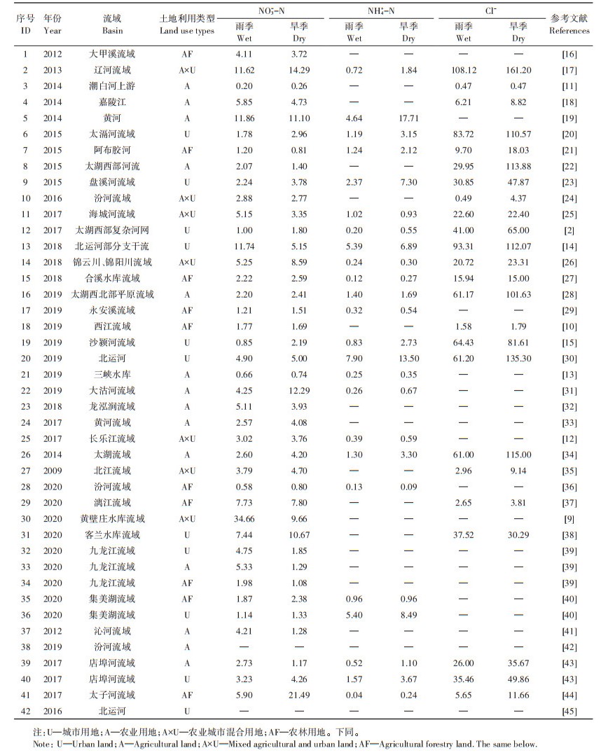
1.2 数据提取对筛选得到的38篇文献进行数据提取,提取内容为旱季、雨季各点位的δ15N-NO3值、δ18O-NO3值、NO3--N、NH4+-N和Cl-浓度。并根据文献对流域的描述将土地利用类型分为农业用地(A)、城市用地(U)、农业城市混合用地(A×U)、农林用地(AF)。
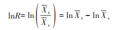
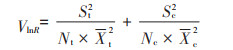
1.3 数据处理为分析旱季、雨季对硝酸盐来源的影响,整合分析采用反应比(Response rate,lnR)或相对比率(Relative rate,RR)两种效应值进行分析,具体如下:
对于浓度和同位素值这类连续型数据,用反应比lnR为效应值,其算法:
|
(1) |
其方差为:
|
(2) |
式中:Xt和Xc分别代表试验组和对照组的所有点位浓度或同位素特征值的平均值;Nt和Nc分别代表试验组和对照组的点位数量;St和Sc分别代表试验组和对照组变量的标准差。本研究设雨季为对照组,旱季为试验组,当lnR > 0时,说明旱季对河流中污染物的浓度有正效应;当lnR=0时,说明旱季、雨季对河流中污染物浓度的影响相同。当P < 0.05时,认为其影响显著。
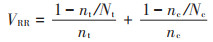
根据δ15N-NO3和δ18O-NO3值将流域各点位的来源分为大气氮沉降(AP)、氮肥(NF)、土壤氮(SON)、粪便与生活污水(M & S)(当点位的δ15N-NO3和δ18O-NO3值属于多个来源时,各来源均记录该点位),记录旱季、雨季研究点位数N和属于各来源的点位数n以获得二分类数据,将雨季设为对照组,旱季为试验组,并以相对比率(RR)为效应值,其算法:

|
(3) |
其方差为:
|
(4) |
式中:nt和nc分别代表试验组和对照组的某一来源的点位数;Nt和Nc分别代表试验组和对照组的研究总点位数。RR > 1时,说明旱季时该来源具有正效应;RR=1时,旱季、雨季时该来源影响相同;95% 置信区间与RR=1相交时,认为影响不显著。
所有统计分析都在R 4.0.2软件中的“meta”和“metafor”包进行,绘图均用Origin软件。
2 结果与讨论 2.1 旱季和雨季河流中污染物浓度的差异分析我国河流中NO3--N、NH4+-N和Cl-浓度如图 1和表 1所示。从图 1中可以看出,旱、雨季NO3--N的浓度分别为0.26~21.50 mg·L-1(均值4.47 mg·L-1)和0.20~34.60 mg·L-1(均值4.59 mg·L-1),旱、雨季NH4+-N的浓度分别为0.09~17.70 mg·L-1(均值3.29 mg·L-1)和0.04~7.90 mg·L-1(均值1.60 mg·L-1),旱、雨季Cl-的浓度分别为0.47~161.20 mg·L-1(均值53.30 mg·L-1)和0.47~108.10 mg·L-1(均值34.30 mg·L-1)。总体而言,3种污染物的浓度在旱季略高于雨季。

|
图 1 我国河流旱、雨季NO3--N、NH4+-N和Cl-浓度 Figure 1 Concentrations of NO3--N, NH4+-N and Cl- in rivers in dry and wet seasons |
|
|
表 1 我国部分流域NO3--N、NH4+-N和Cl-平均浓度(mg·L-1) Table 1 Average concentrations of NO3--N, NH4+-N and Cl- in rivers of China(mg·L-1) |
为了定量比较旱、雨季不同污染物的浓度差异,采用整合分析方法统计了每条河流的旱、雨季差异,结果如图 2所示。旱季时NO3--N、NH4+-N和Cl-浓度均显著高于雨季(P < 0.05),lnR分别为0.20、0.54和0.14,其中lnR越大代表旱季正效应越大,旱季对NH4+-N浓度具有更大正效应。通常来说,气候变化会影响无机氮存在水平,这主要是由于温度变化和降水影响地表径流和其他氮迁移途径[1]。本研究纳入分析的流域集中分布在我国中部和东部地区,属季风气候,特点为旱、雨季分明。在北京郊区[30]、太湖上游河网[2]、山东锦云川和锦阳川流域[26]、黄壁庄水库附近水域[9]、江苏太滆河流域[20]和浙江永安溪流域[29],因雨季降雨量较大,河流中的NO3--N、NH4+-N和Cl-被稀释,因此浓度低于旱季。此外,NH4+-N的lnR值较高,说明气候变化对NH4+-N影响较大。一般来说,NH4+-N主要通过污水输入河流[2],旱季时河流流量较雨季小,因此污水输入对河流总量的贡献率大于雨季。且因雨季气温等因素更利于微生物活动,故在雨季硝化作用强度较高,这也是雨季NH4+-N浓度低于旱季的重要原因[1]。此外,Cl-具有生物地球化学惰性[2],其潜在来源包括肥料、岩石侵蚀、动物粪便及生活污水等,且仅在外源污水汇入时其浓度才改变[14],故可辅助溯源。一般来说,人为污染源的Cl-浓度相对较高[30]。由图 2可知,本研究分析的河流中Cl-的lnR远大于0,这表明研究的流域在旱季受到的人为污染影响强于雨季。总体上,所研究的流域NO3--N、NH4+-N和Cl-浓度旱、雨季差异显著(P < 0.05),这主要因旱、雨季物质来源不同。

|
*表示旱季和雨季具有显著差异(P < 0.05)。下同 * indicates significant difference between dry and wet season. The same below 图 2 旱、雨季河流中NO3--N、NH4+-N和Cl-浓度的差异分析 Figure 2 Analysis on concentrations of NO3--N, NH4+-N and Cl- in dry and wet seasons |
河流中的硝酸盐质量浓度不仅会受到气候变化和人为活动的影响,包括降水量的增加和减少以及人类生产生活的强度,还会受到土地利用类型变化的影响。如图 3所示,农业用地和城市用地的Cl-浓度较高,城市用地的NH4+-N浓度高于其他土地利用类型,农林用地的NO3--N和Cl-浓度低于其他土地利用类型。不同土地利用类型区域旱、雨季污染物浓度存在差异,如图 4所示,土地利用类型为城市用地(U)的流域NO3--N、NH4+-N和Cl-的lnR值分别为0.36、0.81和0.35,旱季时浓度均显著高于雨季(P < 0.05)。土地利用类型为农业用地的流域NO3--N、NH4+-N和Cl-的lnR值分别为0.21、0.60和0.53,旱季时浓度显著高于雨季(P < 0.05)。土地利用类型为农业城市混合用地的流域NO3--N、NH4+-N和Cl-的lnR值分别为0.23、-0.06和0.03,NH4+-N浓度无显著差异(P > 0.05),而旱季NO3--N和Cl-浓度均显著高于雨季(P < 0.05)。土地利用类型为农林用地的流域NO3--N、NH4+-N和Cl-的lnR值分别为0.08、0.40和0.36,NO3--N浓度无显著差异(P > 0.05),旱季NH4+-N和Cl-浓度均显著高于雨季(P < 0.05)。

|
图 3 不同土地利用类型区域河流中NO3--N、NH4+-N和Cl-的浓度 Figure 3 Concentrations of NO3-N, NH4-N and Cl- in rivers of different land use types |

|
U—城市用地;A—农业用地;A×U—农业城市混合用地;AF—农林用地。下同 U—Urban land; A—Agricultural land; A×U—Mixed Agricultural and urban land; AF—Agricultural forestry land. The same below 图 4 不同土地利用类型区域旱、雨季河流中NO3--N、NH4+-N和Cl-浓度的差异分析 Figure 4 Analysis on the concentrations of NO3--N, NH4+-N and Cl- in different land use types |
上述结果表明,流经不同土地利用类型的流域NO3--N、NH4+-N和Cl-质量浓度有很大差别。城市用地流域NH4+-N浓度较高,且NO3--N、NH4+-N的lnR值最大。城市用地包含大量居民区和工业区,人口集中,产生大量城镇生活污水和工业废水,并且NH4+-N主要通过污水输入河流[2],表明城市用地流域主要受废水排放影响[7,17]。而农业用地NO3--N浓度与城市用地相当,但NO3--N的lnR值较小,因此推断农业用地与城市用地硝酸盐浓度影响因素不同。农业用地人口密度较小,但雨季农业活动频繁,施肥量大,导致雨季NO3--N的浓度略高于旱季(图 3),表明农业用地流域硝酸盐污染主要受施肥的影响。农业城市混合用地NO3--N的lnR值介于农业用地和城市用地之间,表明农业城市混合用地流域硝酸盐污染同时受废水排放和施肥双重影响。农林用地常位于远离密集人群的地区,各离子浓度最低(图 3),受人为污染程度最小。但因缺少环境管理,岩石侵蚀作用导致农林用地受Cl-污染[32]。总体上,城市用地、农业用地和农业城市混合用地流域NO3--N浓度相当,受人为污染严重,但其主要影响因素不同;农林用地流域受人为干扰程度小,NO3--N、NH4+-N和Cl-浓度低。
2.3 旱季和雨季河流中硝酸盐来源的差异分析我国河流氮氧同位素特征值如图 5所示,旱、雨季δ15N-NO3特征值分别为1.72‰~17.33‰(均值7.14‰)和-1.26‰~19.96‰(均值6.69‰),旱季的δ15N-NO3均值略高于雨季,说明旱季硝酸盐来源中污水粪便源比例高于雨季。δ18O-NO3特征值分别为-4.63‰~37.16‰(均值7.00‰)和-13.56‰~19.12‰(均值5.55‰),大气沉降源δ18O-NO3特征值范围一般为23‰~80‰[7],但本研究发现我国42条河流中98%的δ18O-NO3特征值低于23‰,这表明大气沉降源不是我国河流硝酸盐主要来源。

|
图 5 我国河流中氮氧同位素的特征值 Figure 5 Isotopic characteristics of nitrogen and oxygen in surface rivers |
河流中硝酸盐来源多样,为探究我国河流总体上在旱、雨季的硝酸盐来源差异,对各来源所含点数进行整合分析(图 6)。结果表明,大气氮沉降源、氮肥源、土壤氮源和粪便污水源的RR值(95% 置信区间)分别为1.32(0.64~2.71)、0.81(0.71~0.92)、0.92(0.80~1.05)和1.04(0.99~1.10),氮肥源和土壤氮源在雨季增强,且氮肥源在雨季强度显著增加,污水与粪便源在旱季增强。农业活动常使用含氮肥料提高农作物产量,全球每年总氮输入为1.366亿t[46],其中一半来自氮肥,但由于氮肥利用率不高,有近2/5的氮输入留在土壤中。在雨季土壤中未被植物利用的氮随地表径流入河,导致来自氮肥源的硝酸盐量在雨季更大。土壤氮源中的硝酸盐主要来源于水土流失入河的含氮土壤颗粒和土壤中微生物活动产生的含氮物质[39]。在雨季,地表径流明显,大量含氮土壤颗粒在淋溶作用下伴随地表径流入河,有研究表明暴雨会导致表层土壤硝态氮损失10.21%[47],且雨季土壤环境更适宜微生物活动[48],因此雨季来自土壤氮源的硝酸盐量高于旱季。总体上,我国河流不同硝酸盐来源在旱、雨季差异较大,在雨季来自氮肥源和土壤氮源的硝酸盐量更高,在旱季来自污水粪便源的硝酸盐量更高。

|
AP—大气氮沉降源;NF—氮肥源;SON—土壤氮源;M & S—粪便与污水源。下同 AP—Atmospheric deposition; NF—Nitrogen fertilizer; SON—Soil nitrogen; M & S—Manure and sewage. The same below 图 6 我国旱、雨季河流中硝酸盐来源的差异分析 Figure 6 Analysis on nitrate sources in dry and wet seasons |
不同土地利用类型流域旱、雨季硝酸盐来源的差异分析如图 7所示,土地利用类型为城市用地的流域,大气沉降源、氮肥源、土壤氮源和污水粪便源的RR值(95% 置信区间)分别为0.68(0.23~1.98)、0.92(0.68~1.24)、1.01(0.73~1.38)和1.10(0.99~1.21)。土地利用类型为农业用地的流域,氮肥源、土壤氮源和粪便污水源的RR值(95% 置信区间)分别为0.77(0.57~1.04)、0.86(0.67~1.12)和0.94(0.86~1.02)。农业和城市混合用地流域,氮肥源、土壤氮源和粪便污水源RR值(95% 置信区间)分别为0.58(0.39~0.86)、1.16(0.70~1.93)和1.23(0.98~1.54)。农林用地流域,氮肥源、土壤氮源和粪便污水源的RR值(95% 置信区间)分别为0.85(0.71~1.02)、0.87(0.71~1.07)和1.07(0.97~1.18)。

|
图 7 不同土地利用类型区域旱、雨季河流硝酸盐来源的差异分析 Figure 7 Analysis on nitrate sources in different land use types |
上述结果表明,不同土地利用类型流域旱、雨季硝酸盐来源的差异较大。如2.2节所述,城市用地流域硝酸盐污染主要受废水(生活污水、工业废水和污水厂出水)排放影响,废水排放量在旱、雨季变化不大,但旱季降雨量少,因而城市用地流域来自污水粪便源的硝酸盐量在旱季占比更大(RR=1.10),点源污染问题在旱季更突出。我国农业用地多数不具备良好排污管网及污水处理设施[33],且雨季农业活动频繁,因此降雨造成的地表径流导致雨季对污水粪便源、氮肥源和土壤氮源的正效应(RR < 1),即来自这三个来源的硝酸盐量在雨季更大。结合2.2节中农业用地流域雨季硝酸盐浓度高于旱季的结果,说明在雨季氮肥源、土壤氮源及污水粪便源是硝酸盐的主要来源,雨季面源污染问题突出。农业城市混合流域兼具城市用地和农业用地的特征,有生活污水等废水的排放并且雨季农业活动频繁,因而旱季点源污染突出(粪便与污水源RR为1.23),雨季面源污染问题突出(氮肥源RR为0.58)。农林用地常远离城市,受人类污染程度较小,其硝酸盐来源主要为土壤和岩石侵蚀作用带来的面源污染。此外,整体来看RR值存在一定的异质性,这是由于不同研究者采用的同位素溯源手段有所差别,并且硝酸盐来源不仅与河流两岸土地利用类型相关,还受流域规模、周边经济发展水平和所处地理位置等因素影响。不同土地利用类型硝酸盐来源存在差异,在治理硝酸盐污染时应考虑其来源,因此以城市用地为主的流域应更加关注废水排放问题,而农业用地流域则需更加关注化肥的合理施用、裸露土地造成的水土流失以及污水管网设施的缺陷问题。此外未来需要结合废水排放量、施肥量、流域规模和经济发展水平建立硝酸盐溯源模型,以便更加准确快速地识别硝酸盐来源。
3 结论(1)我国河流中NO3--N、NH4+-N和Cl-浓度在旱季均显著高于雨季,城市用地、农业用地和农业城市混合用地流域NO3--N浓度相当,农林用地流域受人为干扰程度小,NO3--N、NH4+-N和Cl-浓度较低。
(2)我国河流旱、雨季硝酸盐来源差异较大,大气氮沉降不是我国河流硝酸盐的主要来源,来自氮肥源和土壤氮源的硝酸盐在雨季占比大,而来自污水与粪便源的硝酸盐在旱季占比高。
(3)我国不同土地利用类型流域旱、雨季硝酸盐来源的差异较大,城市用地流域受污水与粪便排放影响(RR=1.10),旱季点源污染问题突出;农业用地流域雨季受氮肥源(RR=0.77)、土壤氮源(RR=0.86)和污水粪便源(RR=0.94)共同影响,面源污染问题突出。
| [1] |
XIA X H, ZHANG S B, LI S L, et al. The cycle of nitrogen in river systems: Sources, transformation, and flux[J]. Environmental Science: Processes & Impacts, 2018, 20(6): 863-891. |
| [2] |
YI Q T, CHEN Q W, HU L M, et al. Tracking nitrogen sources, transformation, and transport at a basin scale with complex plain river networks[J]. Environmental Science & Technology, 2017, 51(10): 5396-5403. |
| [3] |
NESTLER A, BERGLUND M, ACCOE F, et al. Isotopes for improved management of nitrate pollution in aqueous resources: Review of surface water field studies[J]. Environmental Science and Pollution Research, 2011, 18: 519-533. DOI:10.1007/s11356-010-0422-z |
| [4] |
HORD N G. Dietary nitrates, nitrites, and cardiovascular disease[J]. Current Atherosclerosis Reports, 2011, 13: 484-492. DOI:10.1007/s11883-011-0209-9 |
| [5] |
ZHANG Y, SHI P, SONG J X, et al. Application of nitrogen and oxygen isotopes for source and fate identification of nitrate pollution in surface water: A review[J]. Applied Sciences, 2019, 9(1): 18-34. |
| [6] |
HAO Z, ZHANG X Y, GAO Y, et al. Nitrogen source track and associated isotopic dynamic characteristic in a complex ecosystem: A case study of a subtropical watershed, China[J]. Environmental Pollution, 2018, 236: 177-187. DOI:10.1016/j.envpol.2018.01.078 |
| [7] |
JANI J, TOOR G S. Composition, sources, and bioavailability of nitrogen in a longitudinal gradient from freshwater to estuarine waters[J]. Water Research, 2018, 137: 344-354. DOI:10.1016/j.watres.2018.02.042 |
| [8] |
CHEN X, JIANG C L, ZHENG L G, et al. Identification of nitrate sources and transformations in basin using dual isotopes and hydrochemistry combined with a Bayesian mixing model: Application in a typical mining city[J]. Environmental Pollution, 2020, 267: 115651. DOI:10.1016/j.envpol.2020.115651 |
| [9] |
ZHANG Q Q, WANG H W. Assessment of sources and transformation of nitrate in the alluvial-pluvial fan region of north China using a multi-isotope approach[J]. Journal of Environmental Sciences, 2020, 89: 9-22. DOI:10.1016/j.jes.2019.09.021 |
| [10] |
LI C, LI S L, YUE F J, et al. Identification of sources and transformations of nitrate in the Xijiang River using nitrate isotopes and Bayesian model[J]. Science of the Total Environment, 2019, 646: 801-810. DOI:10.1016/j.scitotenv.2018.07.345 |
| [11] |
盛婷, 杨平恒, 谢国文, 等. 基于δ15N和δ18O的农业区地下河硝酸盐污染来源[J]. 环境科学, 2018, 39(10): 4547-4555. SHENG T, YANG P H, XIE G W, et al. Nitrate-nitrogen pollution sources of an underground river in karst agricultural area using 15N and 18O isotope technique[J]. Environmental Science, 2018, 39(10): 4547-4555. |
| [12] |
JI X L, XIE R T, HAO Y, et al. Quantitative identification of nitrate pollution sources and uncertainty analysis based on dual isotope approach in an agricultural watershed[J]. Environmental Pollution, 2017, 229: 586-594. DOI:10.1016/j.envpol.2017.06.100 |
| [13] |
ZHAO Y Y, ZHENG B H, JIA H F, et al. Determination sources of nitrates into the Three Gorges Reservoir using nitrogen and oxygen isotopes[J]. Science of the Total Environment, 2019, 687: 128-136. DOI:10.1016/j.scitotenv.2019.06.073 |
| [14] |
LIU J, SHEN Z Y, YAN T Z, et al. Source identification and impact of landscape pattern on riverine nitrogen pollution in a typical urbanized watershed, Beijing, China[J]. Science of the Total Environment, 2018, 628/629: 1296-1307. DOI:10.1016/j.scitotenv.2018.02.161 |
| [15] |
MA P, LIU S X, YU Q B, et al. Sources and transformations of anthropogenic nitrogen in the highly disturbed Huai River Basin, eastern China[J]. Environmental Science and Pollution Research, 2019, 26: 11153-11169. DOI:10.1007/s11356-019-04470-1 |
| [16] |
PENG T R, LIN H J, WANG C H, et al. Pollution and variation of stream nitrate in a protected high-mountain watershed of central Taiwan: Evidence from nitrate concentration and nitrogen and oxygen isotope compositions[J]. Environmental Monitoring and Assessment, 2012, 184: 4985-4998. DOI:10.1007/s10661-011-2314-1 |
| [17] |
YUE F J, LI S L, LIU C Q, et al. Using dual isotopes to evaluate sources and transformation of nitrogen in the Liao River, northeast China[J]. Applied Geochemistry, 2013, 36: 1-9. DOI:10.1016/j.apgeochem.2013.06.009 |
| [18] |
LI X D, LIU C Q, LIU X L, et al. Sources and processes affecting nitrate in a dam-controlled subtropical river, southwest China[J]. Aquatic Geochemistry, 2014, 20: 483-500. DOI:10.1007/s10498-014-9231-1 |
| [19] |
ZHANG Y, LI F D, ZHANG Q Y, et al. Tracing nitrate pollution sources and transformation in surface-and ground-waters using environmental isotopes[J]. Science of the Total Environment, 2014, 490: 213-222. DOI:10.1016/j.scitotenv.2014.05.004 |
| [20] |
DING J T, XI B D, XU Q G, et al. Assessment of the sources and transformations of nitrogen in a plain river network region using a stable isotope approach[J]. Journal of Environmental Sciences, 2015, 30(4): 198-206. |
| [21] |
LU L, CHENG H G, PU X, et al. Nitrate behaviors and source apportionment in an aquatic system from a watershed with intensive agricultural activities[J]. Environmental Science: Processes & Impacts, 2015, 17: 131-144. |
| [22] |
ZENG H A, WU J L. Tracing the nitrate sources of the Yili River in the Taihu Lake watershed: A dual isotope approach[J]. Water, 2015, 7(1): 188-201. |
| [23] |
ZHANG Q Q, WANG X K, SUN F X, et al. Assessment of temporal and spatial differences of source apportionment of nitrate in an urban river in China, using δ15N and δ18O values and an isotope mixing model[J]. Environmental Science and Pollution Research, 2015, 22: 20226-20233. DOI:10.1007/s11356-015-5674-1 |
| [24] |
ZHI J H, DING A Z, ZHANG S R. Nitrate sources and nitrogen biogeochemical processes in the Feng River in west China inferred from the nitrogen and oxygen dual isotope measurements of nitrate[J]. Desalination and Water Treatment, 2016, 57(18): 8243-8251. DOI:10.1080/19443994.2015.1021845 |
| [25] |
BU H M, SONG X F, ZHANG Y, et al. Sources and fate of nitrate in the Haicheng River basin in northeast China using stable isotopes of nitrate[J]. Ecological Engineering, 2017, 98: 105-113. DOI:10.1016/j.ecoleng.2016.10.052 |
| [26] |
YANG B S, WANG H, JIANG Y K, et al. Combing δ15N and δ18O to identify the distribution and the potential sources of nitrate in human-impacted watersheds, Shandong, China[J]. RSC Advances, 2018, 8(41): 23199-23205. DOI:10.1039/C8RA04364G |
| [27] |
ZHANG M, ZHI Y Y, SHI J C, et al. Apportionment and uncertainty analysis of nitrate sources based on the dual isotope approach and a Bayesian isotope mixing model at the watershed scale[J]. Science of the Total Environment, 2018, 639: 1175-1187. DOI:10.1016/j.scitotenv.2018.05.239 |
| [28] |
DING J T, XI B D, XU Q G, et al. Isotopic evidence of nitrate sources and its transformations in a human-impacted watershed[J]. Environmental Science: Processes & Impacts, 2019, 21(3): 575-583. |
| [29] |
HU M P, LIU Y M, ZHANG Y F, et al. Coupling stable isotopes and water chemistry to assess the role of hydrological and biogeochemical processes on riverine nitrogen sources[J]. Water Research, 2019, 150: 418-430. DOI:10.1016/j.watres.2018.11.082 |
| [30] |
PETERS M, GUO Q J, STRAUSS H, et al. Contamination patterns in river water from rural Beijing: A hydrochemical and multiple stable isotope study[J]. Science of the Total Environment, 2019, 654: 226-236. DOI:10.1016/j.scitotenv.2018.10.423 |
| [31] |
LI Y Q, YAN W J, WANG F, et al. Nitrogen pollution and sources in an aquatic system at an agricultural coastal area of eastern China based on a dual-isotope approach[J]. Environmental Science and Pollution Research, 2019, 26: 23807-23823. DOI:10.1007/s11356-019-05665-2 |
| [32] |
HAN L, HUANG M S, MA M H, et al. Evaluating sources and processing of nonpoint source nitrate in a small suburban watershed in China[J]. Journal of Hydrology, 2018, 559: 661-668. DOI:10.1016/j.jhydrol.2017.04.057 |
| [33] |
YUE F J, LI S L, LIU C Q, et al. Tracing nitrate sources with dual isotopes and long term monitoring of nitrogen species in the Yellow River, China[J]. Scientific Reports, 2017, 7: 8537. DOI:10.1038/s41598-017-08756-7 |
| [34] |
DING J T, XI B D, GAO R T, et al. Identifying diffused nitrate sources in a stream in an agricultural field using a dual isotopic approach[J]. Science of the Total Environment, 2014, 484: 10-18. DOI:10.1016/j.scitotenv.2014.03.018 |
| [35] |
CHEN F J, JIA G D, CHEN J Y. Nitrate sources and watershed denitrification inferred from nitrate dual isotopes in the Beijiang River, south China[J]. Biogeochemistry, 2009, 94: 163-174. DOI:10.1007/s10533-009-9316-x |
| [36] |
ZHAO Y, DANG J H, WANG F, et al. Sources of nitrogen pollution in upstream of fenhe river reservoir based on the nitrogen and oxygen stable isotope[J]. Journal of Chemistry, 2020, 2020, 6574210. |
| [37] |
ZHAO H J, XIAO Q, MIAO Y, et al. Sources and transformations of nitrate constrained by nitrate isotopes and Bayesian model in karst surface water, Guilin, southwest China[J]. Environmental Science and Pollution Research, 2020, 27(17): 21299. DOI:10.1007/s11356-020-08612-8 |
| [38] |
JIN Z X, WANG J F, CHEN J G, et al. Identifying the sources of nitrate in a small watershed using δ15N-δ18O isotopes of nitrate in the Kelan reservoir, Guangxi, China[J]. Agriculture, Ecosystems & Environment, 2020, 297: 106936. |
| [39] |
HUANG Y L, HUANG J L, ERVINIA A, et al. Tracking riverine nitrate sources under changing land use pattern and hydrologic regime[J]. Marine Pollution Bulletin, 2020, 152: 110884. DOI:10.1016/j.marpolbul.2020.110884 |
| [40] |
GUO Z F, YAN C Z, WANG Z S, et al. Quantitative identification of nitrate sources in a coastal peri-urban watershed using hydrogeochemical indicators and dual isotopes together with the statistical approaches[J]. Chemosphere, 2020, 243: 125364. DOI:10.1016/j.chemosphere.2019.125364 |
| [41] |
张东, 杨伟, 赵建立. 氮同位素控制下黄河及其主要支流硝酸盐来源分析[J]. 生态与农村环境学报, 2012, 28(6): 622-627. ZHANG D, YANG W, ZHAO J L. Tracing nitrate sources of the Yellow River and its tributaries with nitrogen isotope[J]. Journal of Ecology and Rural Environment, 2012, 28(6): 622-627. DOI:10.3969/j.issn.1673-4831.2012.06.003 |
| [42] |
杨锐婧, 冯民权, 汪银龙. 汾河下游丰水和枯水期的河流硝酸盐污染来源特征[J]. 水土保持通报, 2019, 39(6): 211-217. YANG R J, FENG M Q, WANG Y L. Source characteristics of nitrate pollution in Fenhe River during high and low water periods[J]. Bulletin of Soil and Water Conservation, 2019, 39(6): 211-217. |
| [43] |
王静, 叶寅, 王允青, 等. 利用氮氧同位素示踪技术解析巢湖支流店埠河硝酸盐污染源[J]. 水利学报, 2017, 48(10): 1195-1205. WANG J, YE Y, WANG Y Q, et al. Using δ15N and δ18O values to identify sources of nitrate in the Dianbu River in the Chaohu Lake basin[J]. Journal of Hydraulic Engineering, 2017, 48(10): 1195-1205. |
| [44] |
李艳利, 孙伟, 杨梓睿. 太子河流域中游地区河流硝酸盐来源及迁移转化过程[J]. 环境科学, 2017, 38(12): 5039-5046. LI Y L, SUN W, YANG Z R. Identification of nitrate sources and transformation processes in midstream areas: A case in the Taizi River basin[J]. Environmental Science, 2017, 38(12): 5039-5046. |
| [45] |
赵庆良, 马慧雅, 任玉芬, 等. 利用δ15N-NO3-和δ18O-NO3-示踪北京城区河流硝酸盐来源[J]. 环境科学, 2016, 37(5): 1692-1698. ZHAO Q L, MA H Y, REN Y F, et al. δ15N-NO3- and δ18O-NO3- tracing of nitrate sources in Beijing urban rivers[J]. Environmental Science, 2016, 37(5): 1692-1698. |
| [46] |
LIU J G, YOU L Z, AMINI M, et al. A high-resolution assessment on global nitrogen flows in cropland[J]. Proceedings of the National Academy of Sciences of the United States of America, 2010, 107(17): 8035-8040. DOI:10.1073/pnas.0913658107 |
| [47] |
刘操, 马宁, 龚明波. 模拟降雨条件下北运河流域农田养分流失特征[J]. 农业资源与环境学报, 2016, 33(3): 238-243. LIU C, MA N, GONG M B. Characteristic of soil nutrients loss in Beiyunhe reservoir under the simulated rainfall[J]. Journal of Agricultural Resources and Environment, 2016, 33(3): 238-243. |
| [48] |
张翠景, 贺纪正, 沈菊培. 全球变化野外控制试验及其在土壤微生物生态学研究中的应用[J]. 应用生态学报, 2016, 27(5): 1663-1673. ZHANG C J, HE J Z, SHEN P J. Global change field manipulative experiments and their applications in soil microbial ecology[J]. Chinese Journal of Applied Ecology, 2016, 27(5): 1663-1673. |