 2019, Vol. 36


滨海湿地位于陆地生态系统和海洋生态系统的过渡地带,是海岸带的重要组成部分,也是地球上极为活跃、敏感和脆弱的湿地类型之一[1],其在维持生物多样性、调蓄洪水、净化水质、调节气候和保障区域生态安全等方面发挥着不可替代的作用,对地区乃至全球的气候变化、人类生存环境及社会经济发展都有至关重要的意义[2]。近年来,我国滨海湿地退化严重,其中外来物种入侵是一个重要的影响因素[3-4]。互花米草因具有极强的繁殖能力、耐高盐、耐高频率淹没且无天敌限制,而成为最主要的入侵物种[5],威胁滨海湿地的生态结构和功能[6-7]。
随着社会经济快速发展,土地供需矛盾日益突出,沿海滩涂围垦工程的实施成为缓解这一矛盾的重要途径之一[8]。1985—2010年,我国滨海地区围垦海岸带湿地面积超过7500 km2,强度较大的区域主要分布在江苏、浙江及环渤海地区[9-10]。围垦开发加速了滨海湿地的陆向演化过程,与天然滨海湿地相比,围垦工程阻隔了潮汐,改变了植物的生境[11],进而影响种群的扩张[12-13]。而潮汐是互花米草种子传播的一个重要途径,水盐也是制约互花米草扩张的一个重要影响因素[14],同时围垦大堤外泥沙淤积造成的高程变化及潮汐淹水也影响互花米草种群的生长与发育[15]。而关于围垦工程的实施对其入侵或扩张的影响程度方面的研究仍待加强。
目前我国滨海湿地面积约5.80×10⁴ km2,多集中分布在人口最为密集、经济最为发达的地区[16],仅江苏省内的滨海湿地就占到25%,主要分布于盐城[17],且互花米草在盐城滨海湿地的分布面积最大[18]。已有研究发现,互花米草在盐城滨海湿地有大幅扩张,其面积在1996— 2010年15年间增加了26.61 km2,增幅达215.42%;景观质心每年平均向海移动74.97 m,景观格局发生明显变化[19]。2010年后,盐城自然保护区内互花米草斑块不断扩大,其景观呈现由南向北移动的趋势[20]。因此,本研究以江苏省盐城条子泥滨海湿地为研究地点,借助无人机遥感技术,观测围垦区内外互花米草的面积动态变化;结合实地土壤水盐的监测,探析围垦工程对互花米草生长扩张的影响;利用无人机航测建立观测区地形,探析高程与种群生长之间的联系;测定地表水深,探究地表水深对互花米草种群扩张的影响。其结果可以为抑制互花米草的入侵提供重要的参考。
1 研究区概况研究区位于盐城市弶港镇海岸的条子泥沙洲,北起粱垛河口外,南至新川港口外,西边至苏北中部沿海垦区外堤线,东至高泥外缘,南北长约40 km,东西宽约40 km。围垦工程于2012年2月开工,2013年10月底围垦大堤建成(图 1)。该区域地处我国典型季风气候区,受海洋性和大陆性气候双重影响,年均气温为14 ℃,年均降水量1000 mm。黄海旋转波和东海前进波在该地区汇合,因而该处潮流状况复杂,表现为潮差大,最大潮差可达6.68 m[21-22];潮滩变化速度快,潮滩淤积明显,以50~100 m·a-1的速度向海推进,是江苏沿海地区淤长速度较快的岸段[23]。

|
图 1 研究区位置和范围 Figure 1 Location and scope of the study area |
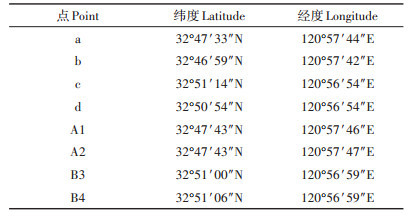
在条子泥沙洲的围垦大堤内外分别选定1个约1 km2互花米草生长的地块作为研究对象。围垦工程的实施将土地隔离成固定大小(1.5 km×0.7 km)的若干块,选取其中未被开发的地块作为研究对象B,同时在堤外选取面积相近的地块A作为研究对象。地块A为天然条件,地块B为围垦后的环境。地块A、B区域内仅有单一互花米草分布,并在互花米草生长连片区各设两个土壤采样点,保证土壤样品的代表性。样点分别记为A1、A2和B3、B4,见图 1,详细地理坐标见表 1。
|
|
表 1 采样点和定点经纬度坐标 Table 1 Coordinates of latitude and longitude for sampling sites |
本研究采用大疆无人机(DJI-M600)搭载禅思X5相机采集互花米草种群分布影像,于2017年5、7、9、11月及2018年1、3、5、7月共进行8次观测,确保年季观测的完整性。在满足飞行安全的气象条件下,设定无人机沿航线进行倾斜摄影,采集图像。经过多次飞行确定飞行高度为75 m、拍照间隔为3 s、航向重叠度为80%、旁向重叠度为60%,以保证生成影像的质量。采集的影像数据经对齐照片、建立密集点云、生成网格、生成纹理后,最终生成正射影像(DOM,分辨率3 cm)。在合理选择分类样本的基础上,对DOM监督分类和聚类处理,去除由于缺乏空间连续性而形成的斑点或空洞偏差,进而估算植被覆盖面积。
2.2 土壤水盐测定于2018年1、3、5、7、10月小潮退后2 h,采集表层土壤(10~15 cm,互花米草根系主要生长范围)。每个样点平行采集2个样品,监测期间,共采集样品40个。样品采集结束后,立即用铝盒密封带回实验室,分别用烘箱和水质检测仪(YSI)测定土壤水盐含量[24-25]。
2.3 高程测定及株高提取利用无人机倾斜摄影技术于2018年3月构建数字表面模型(DSM),该模型包含了研究区域内植被顶端高程。利用平坦地区地形起伏小的特点,编写滤波程序以实现剔除植被顶端高程,获取数字高程模型(DEM)[26]。用上述过程中的DSM值减去DEM值,则可得到该研究区域内的互花米草种群的株高。
2.4 地表水深测定在地块A建立地表水位观测桩,将水位计(Sonist)放入观测桩中,采集频率设定为5 min,共采集2018年4月12日—2018年7月12日共3个月的地表水位数据。
3 结果与讨论 3.1 互花米草种群的面积年季变化观测期间(2017年5月—2018年7月),A和B地块互花米草种群面积发生了明显的年季变化(图 2、图 3)。由图 3可知,围垦后的地块B内互花米草面积由观测伊始的106 111 m2扩张到128 243 m2,增幅为21%;而未被围垦的地块A则由观测伊始的3640 m2扩张为19 070 m2,增幅超过400%。可见,围垦对互花米草种群的扩张有明显的抑制作用。季节上,围垦后的地块B内互花米草种群快速扩张主要在秋季(2017年9—11月),扩张范围集中在y方向130~650 m区间,以种群主体向外扩张的方式进行(图 2和图 3b)。未围垦的地块A互花米草种群快速扩张主要发生夏季(2017年7—9月),扩张范围集中在y方向0~ 400 m和600~800 m两个区间,以新生斑块的方式进行(图 2和图 3b)。

|
图 2 地块A和B互花米草分布影像 Figure 2 Distribution image of Spartina alterniflora population |

|
图 3 互花米草种群面积(a)及增加幅度(b) Figure 3 Area (a) and increasing rates (b) of the Spartina alterniflora population |
造成互花米草种群这种年季扩张特征的原因可能与其繁殖方式密切相关。大堤的建成,阻断了潮水,进而阻断了互花米草种子传播并进入围垦后的地块B,致使区域互花米草以无性繁殖为主。无性繁殖模式下,5—6月及9—10月为互花米草两个分蘖盛期,但5—6月地下部分根茎生长缓慢,而在9—10月地下根茎迅速向外生长、分蘖,种群快速扩张,这与陈圆等[27]在室内研究互花米草根茎繁育的结果基本一致。而大堤的建成,对未围垦地块A影响较少,互花米草种群的扩张仍以有性繁殖为主,这与崇明东滩湿地的观测结果吻合[28]。潮汐将大量互花米草种子和幼苗携带至潮滩前沿,进入5月后,随气温的上升,种子萌发,新生斑块建立,并在7月后开始抽穗、开花,斑块增大,区域种群面积迅速扩张[29]。另有研究发现,有性繁殖体(种子/种苗)的传播尤其是远距离的传播是种群大尺度扩张的关键,而无性繁殖主要利于种群的局部扩张[30-32]。上述差异造成了地块A和B互花米草扩张速度的年季差异。
堤内互花米草无性繁殖扩张的季节性特征为采取相应措施控制互花米草种群的扩张提供了科学参考与依据。由于9—10月后互花米草营养集中在地下,地下根茎迅速生长,再生能力较强,应避免在该时间进行刈割,而应选择6—7月互花米草的穗分化期、孕穗期至抽穗期进行刈割,达到最优的控制效果。
3.2 土壤水盐的年季变化围垦改变了地块A、B土壤水盐状况,围垦区内的地块B的土壤含水率及盐度分别较围垦区外地块A平均降低25%和50%,见图 4。季节上,两地块的土壤盐度均呈春秋高而夏冬低的趋势,而地块A与地块B土壤含水率则基本是相反变化趋势。

|
图 4 土壤含水率(a)及盐度(b)变化 Figure 4 Variations of soil moisture (a) and salinity (b) |
湿润气候下,滨海盐渍土盐度和含水率季节性变化明显,表现为春秋季积盐而夏冬季脱盐[31]。这是由于春秋季降水较少,蒸发强,土壤积盐明显,含水率降低;夏季降水多,淋洗作用明显,土壤盐分偏低,含水率增高;冬季温度低,蒸发较弱,降雨增多,土壤盐分偏低,含水率较高[33-34]。受此影响,围垦后地块B含水率与盐度成相反变化趋势,但地块A受潮汐影响,土壤中的水分由海水补给,盐分随潮水的运动而迁移,故未围垦地块A水分与盐度变化趋势相同。
3.3 互花米草种群面积与土壤水盐关联性分析互花米草的生长与扩张受土壤水盐含量的调控作用影响较大[14]。选择2018年1—7月互花米草种群面积增幅与水盐含量相对应的16组数据,利用SPSS 22.0分析堤内外水盐含量与互花米草种群面积月增幅的关联性,结果表明互花米草种群面积的月增幅与土壤含水率、盐度均呈显著正相关关系(图 5),这与互花米草生长的最适水盐条件密切相关。李伟等[35]的研究发现,互花米草株高、地上生物量及地下生物量都随盐度的增加呈先增后减的趋势,其生长的最适盐度为104 mg·kg-1。另有研究发现,一定范围内,较高的土壤含水率提高了互花米草株高及克隆存活率,促进了种子的萌发与实生苗的生长[36-37]。潮汐淹没频率的增加,也可刺激互花米草无性分株的生成,淹水深度的增加,也明显提高了无性分株的数量及种子的存活率。本研究条子泥围垦区外A地块土壤表层盐度与互花米草的最适盐度相近(图 4b),且存在一定的淹水和潮汐,利于区域内互花米草生长和扩张;而围垦地块B盐度低于互花米草的最适盐度(图 4b),且无潮汐现象,区域互花米草的生长受到一定的抑制。该现象为研究滨海湿地互花米草种群演变规律提供了参考,同时为今后科学合理地安排淹水措施治理互花米草提供了科学依据。

|
图 5 土壤含水率(a)、盐度(b)与面积增幅的关系 Figure 5 Correlations between increasing rates of area and soil moisture (a) and salinity (b) |
利用无人机测量地块A内2018年3月的含植被区域(1000 km×300 km)的DSM,并计算DEM,见图 6。

|
图 6 2018年3月地块A的DSM和DEM值 Figure 6 Value of DSM and DEM(March 2018)at the A region |
提取株高过程中,由于获取DEM的滤波算法的限制,容易造成大片植被分布区域的高程一致,故在植株高度数据中剔除所在位置高程一致的数据样点,减少对相关性分析的影响。将提取的互花米草株高、对应的生长地高程进行关联分析,如图 7所示,互花米草植株高度与生长地高程之间存在显著的正相关性(P < 0.01)。这表明互花米草种群与高程变化之间存在着正反馈机制:天然条件下,植被迎击水流,降低紊流状态的动能,加速了悬沙的沉降,促进了泥沙的淤积,造成潮滩高程的增加[38]。随着高程的增加,盐沼植被的淹水时间减少,根系透氧性得到改善,同时泥沙淤积提供了更多营养物质,刺激分蘖株的萌发及幼苗的营养体繁殖,有利于种群的扩张、定居及生长[39]。由此可见高程变化对互花米草种群的生长与扩张具有重要意义。围垦工程的实施,阻断了泥沙随潮水进入围垦区,围垦区内地形保持稳定,不存在天然条件下种群与高程间的正向反馈机制,种群扩张较缓。

|
图 7 互花米草株高与生长地高程关系 Figure 7 Correlations between height of Spartina alterniflora and elevation |
高程变化不仅受植被条件调控,同时受来沙量及水流条件影响,最终高程反馈作用于植被的扩张和生长。结合年季性的泥沙变化,进一步揭示高程对互花米草种群年季变化的影响是今后的一个研究重点。
围垦大堤的修建,隔绝了潮水进入围垦区,造成了围垦区内无潮水往复侵蚀。地表水位动态变化如图 8所示,计算可得平均水深为0.36 m,地表水平均高程为11.144 m。

|
图 8 地表水位变化 Figure 8 Changes of surface water level |
在ArcGIS 12.0中用2018年3月DEM减去地表水平均高程,经裁剪最终可得地块A互花米草样带地表水深分布(图 9,负值表示在平均地表水平面以下)。对比2018年3月植被分布影像,将植被分布带划分成20组子样带。按照空间代替时间的方法,互花米草种群不断向海方向扩张,远离大堤的互花米草斑块为近期的新生斑块,故各子样带中斑块距大堤的最远距离可以表征种群的最大扩张能力。

|
图 9 地表水深及互花米草子样带分布 Figure 9 Depth of surface water and distribution of Spartina alterniflora |
分别计算20组子样带的平均水深,提取斑块距大堤最远距离,分析两者的关联(图 10),结果表明淹没水深与互花米草种群的扩张距离呈显著正相关关系(P < 0.01)。地表水深的增加有效地促进了无性分株的生成,提高了种子的存活率,有利于新的种群斑块建立,实现了互花米草种群的扩张[40];堤内无潮水侵蚀,缺乏潮水的刺激效应,种群扩张受限。

|
图 10 地表水深与距大堤最远距离的关系 Figure 10 Correlations between depth of surface water and the furthest distance from the embankment |
围垦工程除了造成堤内外水盐含量、淹水、高程变化的差异,还会影响土壤其他理化性质,如土壤氮磷和有机质含量等,进而影响互花米草种群的生长及扩张[41-42]。
4 结论(1) 围垦显著降低了堤内互花米草的扩张速度,观测期内堤内互花米草种群面积增幅为21%,而堤外超过400%。堤内外种群扩张的季节性差异明显,主要扩张时间分别为秋季和夏季。
(2) 围垦大堤阻隔了潮水,改变了堤内外土壤水盐含量,阻断了堤内互花米草种子随潮水传播的途径,抑制了其种群的有性扩张,进而改变了堤内外互花米草扩张的年季特征。
(3) 围垦堤内无淹水影响及泥沙交换引起的高程变化,缺乏淹水及高程变化的促进作用,故种群的生长及扩张较堤外受到更大的限制。
| [1] |
张濛, 濮励杰. 近30年来江苏省滨海湿地变化过程及其受围垦活动的影响[J]. 湿地科学与管理, 2017, 13(3): 56-60. ZHANG Meng, PU Li-jie. The changing process of coastal wetlands and the effects of reclamation in Jiangsu Province in recent 30 years[J]. Wetland Science and Management, 2017, 13(3): 56-60. DOI:10.3969/j.issn.1673-3290.2017.03.11 |
| [2] |
王磊, 何冬梅, 江浩, 等. 江苏滨海湿地生态系统服务功能价值评估[J]. 生态科学, 2016, 35(5): 169-175. WANG Lei, HE Dong-mei, JIANG Hao, et al. Evaluation of coastal wetland ecosystem services in Jiangsu Province[J]. Ecological Science, 2016, 35(5): 169-175. |
| [3] |
Cui L L, Li G S, Ouyang N L, et al. Analyzing coastal wetland degradation and its key restoration technologies in the coastal area of Jiangsu, China[J]. Wetlands, 2018, 38(3): 525-537. DOI:10.1007/s13157-018-0997-6 |
| [4] |
Jiang T T, Pan J F, Pu X M, et al. Current status of coastal wetlands in China:Degradation, restoration, and future management[J]. Estuarine, Coastal & Shelf Science, 2015, 164: 265-275. |
| [5] |
Long T, Yang G, Bo L, et al. Spartina alterniflora with high tolerance to salt stress changes vegetation pattern by outcompeting native species[J]. Ecosphere, 2016, 5(9): 1-18. |
| [6] |
Gao X, Wang M, Wu H, et al. Effects of Spartina alterniflora invasion on the diet of mangrove crabs(Parasesarma plicata)in the Zhangjiang Estuary, China[J]. Journal of Coastal Research, 2018, 34(1): 106-113. |
| [7] |
Valérie S P, Gérard T. Marine species introduced on the French Channel-Atlantic coasts:A review of main biological invasions and impacts[J]. Open Journal of Ecology, 2015, 5(5): 227-257. DOI:10.4236/oje.2015.55019 |
| [8] |
尹延鸿, 尹聪. 围海及填海造地的起因、发展及问题[J]. 自然杂志, 2014, 36(6): 437-444. YIN Yan-hong, YIN Cong. The reasons, development and problems of the land reclamation[J]. Chinese Journal of Nature, 2014, 36(6): 437-444. |
| [9] |
周云轩, 田波, 黄颖, 等. 我国海岸带湿地生态系统退化成因及其对策[J]. 中国科学院院刊, 2016, 31(10): 1157-1166. ZHOU Yun-xuan, TIAN Bo, HUANG Ying, et al. Degradation of coastal wetland ecosystem in China:Drivers, impacts, and strategies[J]. Bulletin of Chinese Academy of Sciences, 2016, 31(10): 1157-1166. |
| [10] |
Tian B, Wu W, Yang Z, et al. Drivers, trends, and potential impacts of long-term coastal reclamation in China from 1985 to 2010[J]. Estuarine, Coastal and Shelf Science, 2016, 170: 83-90. DOI:10.1016/j.ecss.2016.01.006 |
| [11] |
戚志伟, 高艳娜, 樊同, 等. 崇明东滩围垦湿地芦苇生态特征与水盐因子的关系[J]. 应用与环境生物学报, 2016, 22(5): 739-746. QI Zhi-wei, GAO Yan-na, FAN Tong, et al. Relationship between ecological characteristics of Phragmites australis and water-salt indicators in the reclaimed wetland at Dongtan of Chongming Island, China[J]. Chinese Journal of Applied and Environmental Biology, 2016, 22(5): 739-746. |
| [12] |
Glaeser L C, Vitt D H, Ebbs S. Responses of the wetland grass, Beckmannia syzigachne, to salinity and soil wetness:Consequences for wetland reclamation in the oil sands area of Alberta, Canada[J]. Ecological Engineering, 2016, 22(6): 24-30. |
| [13] |
Li C, Tao Y, Meng Z, et al. Soil characteristics and their potential thresholds associated with Scirpus mariqueter distribution on a reclaimed wetland coast[J]. Journal of Coastal Conservation, 2018, 5(12): 1-10. |
| [14] |
Wang C, Pei X, Yue S, et al. The response of Spartina alterniflora biomass to soil factors in Yancheng, Jiangsu Province, P R China[J]. Wetlands, 2016, 36(2): 229-235. DOI:10.1007/s13157-016-0732-0 |
| [15] |
潘宇, 李德志, 袁月, 等. 崇明东滩湿地芦苇和互花米草种群的分布格局及其与生境的相关性[J]. 植物资源与环境学报, 2012, 21(4): 1-9. PAN Yu, LI De-zhi, YUAN Yue, et al. Distribution pattern of Phragmites australis and Spartina alterniflora populations in Chongming Dongtan wetland and its correlation with habitat[J]. Journal of Plant Resources and Environment, 2012, 21(4): 1-9. |
| [16] |
李晶, 雷茵茹, 崔丽娟, 等. 我国滨海滩涂湿地现状及研究进展[J]. 林业资源管理, 2018(2): 24-28. LI Jing, LEI Yin-ru, CUI Li-juan, et al. Current status and research progress of coastal tidal flat wetlands in China[J]. Forest Resources Management, 2018(2): 24-28. |
| [17] |
姚志刚, 陈玉清, 袁芳, 等. 江苏省滨海湿地现状、问题及保护对策[J]. 林业工程学报, 2014, 28(4): 10-14. YAO Zhi-gang, CHEN Yu-qing, YUAN Fang, et al. Status, problems and protection countermeasures of coastal wetlands in Jiangsu Province[J]. Journal of Forestry Engineering, 2014, 28(4): 10-14. |
| [18] |
张华兵, 刘红玉, 侯明行. 人工管理和自然驱动下盐城海滨湿地互花米草沼泽演变及空间差异[J]. 生态学报, 2013, 33(15): 4767-4775. ZHANG Hua-bing, LIU Hong-yu, HOU Ming-hang. Spatiotemporal characteristics of Spartina alterniflora marsh change in the coastal wetlands of Yancheng caused by natural processes and human activities[J]. Acta Ecological Sinica, 2013, 33(15): 4767-4775. |
| [19] |
王聪, 刘红玉. 江苏淤泥质潮滩湿地互花米草扩张对湿地景观的影响[J]. 资源科学, 2014, 36(11): 2413-2422. WANG Cong, LIU Hong-yu. The impact of Spartina alterniflora expansion on vegetation landscapes in the Yancheng tidal flat wetland[J]. Resources Science, 2014, 36(11): 2413-2422. |
| [20] |
刘明月.中国滨海湿地互花米草入侵遥感监测及变化分析[D].北京: 中国科学院大学, 2018. LIU Ming-yue. Remote sensing analysis of Spartina alterniflora in the coastal areas of China during 1990 to 2015[D]. Beijing: University of Chinese Academy of Sciences, 2018 http://cdmd.cnki.com.cn/Article/CDMD-80062-1018961863.htm |
| [21] |
涂琦乐, 刘晓东, 华祖林, 等. 条子泥围垦工程对近海生态环境的影响[J]. 河海大学学报(自然科学版), 2015, 43(6): 542-547. TU Qi-le, LIU Xiao-dong, HUA Zu-lin, et al. Effect of Tiaozini reclamation project on offshore ecological environment[J]. Journal of Hohai University(Natural Sciences), 2015, 43(6): 542-547. |
| [22] |
陈才俊, 徐向红. 条子泥一期工程对条子泥发育影响及工程防护措施[J]. 海洋工程, 2015, 33(5): 105-112. CHEN Cai-jun, XU Xiang-hong. Influence of Tiaozini first-phase project on Tiaozini development and project protection measures[J]. The Ocean Engineering, 2015, 33(5): 105-112. |
| [23] |
马洪羽, 丁贤荣. 江苏岸外条子泥潮滩地形遥感遥测模拟[J]. 地理与地理信息科学, 2016, 32(1): 78-83. MA Hong-yu, DING Xian-rong. Remote sensing and remote measuring approach to simulate the Tiaozini tidal flat terrain field off Jiangsu coast[J]. Geography and Geo-Information Science, 2016, 32(1): 78-83. DOI:10.3969/j.issn.1672-0504.2016.01.015 |
| [24] |
徐爱珍, 胡建民, 熊永, 等. TDR法、干烧法及烘干法测定土壤含水量的比较研究[J]. 水资源与水工程学报, 2018, 138(2): 256-259. XU Ai-zhen, HU Jian-min, XIONG Yong, et al. Comparison of soil moisture measurement using TDR method, dry burning method and oven drying method[J]. Journal of Water Resources & Water Engineering, 2018, 138(2): 256-259. |
| [25] |
迟春明, 王志春. 苏打盐渍土草原植被群落分布与土壤理化性质相互关系[J]. 生态学杂志, 2013, 32(9): 2245-2249. CHI Chun-ming, WANG Zhi-chun. Interrelationships between grassland plant community distribution and soil physical and chemical properties in soda-saline soil regions of Songnen Plain, northeast China[J]. Chinese Journal of Ecology, 2013, 32(9): 2245-2249. |
| [26] |
李忠, 李梅, 杜绪奎. 平坦地区DSM到DEM的试验[J]. 测绘与空间地理信息, 2008, 31(2): 29-31. LI Zhong, LI Mei, DU Xu-kui. DSM to DEM in flat area[J]. Geomatics and Spatial Information Technology, 2008, 31(2): 29-31. DOI:10.3969/j.issn.1672-5867.2008.02.010 |
| [27] |
陈圆, 曾兆华, 秦晓静, 等. 互花米草移栽种群无性繁殖的月动态[J]. 生物安全学报, 2014, 23(3): 173-177. CHEN Yuan, ZENG Zhao-hua, QIN Xiao-jing, et al. Monthly variation of asexual reproduction of Spartina alterniflora(Loisel)[J]. Journal of Biosafety, 2014, 23(3): 173-177. DOI:10.3969/j.issn.2095-1787.2014.03.006 |
| [28] |
Ge Z M, Zhang L Q, Yuan L. Spatiotemporal dynamics of salt marsh vegetation regulated by plant invasion and abiotic processes in the Yangtze Estuary:Observations with a modeling approach[J]. Estuaries & Coasts, 2015, 38(1): 310-324. |
| [29] |
Ge Z M, Cao H B, Zhang L Q. A process-based grid model for the simulation of range expansion of Spartina alterniflora on the coastal saltmarshes in the Yangtze Estuary[J]. Ecological Engineering, 2013, 58: 105-112. DOI:10.1016/j.ecoleng.2013.06.024 |
| [30] |
Liu H, Lin Z, Qi X, et al. The relative importance of sexual and asexual reproduction in the spread of Spartina alterniflora using a spatially explicit individual-based model[J]. Ecological Research, 2014, 29(5): 905-915. DOI:10.1007/s11284-014-1181-y |
| [31] |
Trevor C, Ferguson J M, Lichstein J W, et al. The importance of longdistance seed dispersal for the demography and distribution of a canopy tree species[J]. Ecology, 2016, 95(4): 952-962. |
| [32] |
Kendrick G A, Waycott M, Carruthers T J B, et al. The central role of dispersal in the maintenance and persistence of seagrass populations[J]. Bioscience, 2012, 62(1): 56-65. DOI:10.1525/bio.2012.62.1.10 |
| [33] |
赵秀芳, 杨劲松, 姚荣江. 苏北典型滩涂区土壤盐分动态与水平衡要素之间的关系[J]. 农业工程学报, 2010, 26(3): 52-57. ZHAO Xiu-fang, YANG Jin-song, YAO Rong-jiang. Relationship between soil salt dynamics and factors of water balance in the typical coastal area of northern Jiangsu Province[J]. Transactions of the CSAE, 2010, 26(3): 52-57. |
| [34] |
何斌.湿润气候下滨海盐土水盐动态及影响因素研究[D].上海: 华东师范大学, 2014. HE Bin. Study on dynamic of soil moisture content and salinity and its influencing factors in coastal saline soil under humid climate[D]. Shanghai: East China Normal University, 2014 http://cdmd.cnki.com.cn/Article/CDMD-10269-1015542971.htm |
| [35] |
李伟, 袁琳, 张利权, 等. 海三棱藨草及互花米草对模拟盐胁迫的响应及其耐盐阈值[J]. 生态学杂志, 2018, 37(9): 2596-2602. LI Wei, YUAN Lin, ZHANG Li-quan, et al. Responses of Scirpus mariqueter and Spartina alterniflora to simulated salt stress and salt tolerance thresholds[J]. Chinese Journal of Ecology, 2018, 37(9): 2596-2602. |
| [36] |
何军, 赵聪蛟, 清华, 等. 土壤水分条件对克隆植物互花米草表型可塑性的影响[J]. 生态学报, 2009, 29(7): 3518-3524. HE Jun, ZHAO Cong-jiao, QING Hua, et al. Effect of soil-water condition on morphological plasticity of clonal plant Spartina alterniflora[J]. Acta Ecologica Sinica, 2009, 29(7): 3518-3524. DOI:10.3321/j.issn:1000-0933.2009.07.009 |
| [37] |
徐伟伟, 王国祥, 刘金娥, 等. 苏北海滨湿地互花米草种子特征及实生苗生长[J]. 生态学报, 2011, 31(16): 4560-4567. XU Wei-wei, WANG Guo-xiang, LIU Jin-e, et al. Seed characteristics and seedling growth of Spartina alterniflora on coastal wetland of north Jiangsu[J]. Acta Ecologica Sinica, 2011, 31(16): 4560-4567. |
| [38] |
Duarte C M, Losada I J, Hendriks I E, et al. The role of coastal plant communities for climate change mitigation and adaptation[J]. Nature Climate Change, 2013, 3(11): 961-968. DOI:10.1038/nclimate1970 |
| [39] |
Shen Y M, Yang J S, Wang Y H, et al. Impact of sediment supply on spartina salt marshes[J]. Pedosphere, 2008, 18(5): 593-598. DOI:10.1016/S1002-0160(08)60053-3 |
| [40] |
Xue L, Li X Z, Zhang Q, et al. Elevated salinity and inundation will facilitate the spread of invasive Spartina alterniflora in the Yangtze River Estuary, China[J]. Journal of Experimental Marine Biology & Ecology, 2018, 506: 144-154. |
| [41] |
金宝石, 闫鸿远, 王维奇, 等. 互花米草入侵下湿地土壤碳氮磷变化及化学计量学特征[J]. 应用生态学报, 2017, 28(5): 1541-1549. JIN Bao-shi, YAN Hong-yuan, WANG Wei-qi, et al. Changes of soil carbon, nitrogen and phosphorus and stoichiometry characteristics in marsh invaded by Spartina alterniflora[J]. Chinese Journal of Applied Ecology, 2017, 28(5): 1541-1549. |
| [42] |
Hollis I O, Turner R E. The tensile root strength of Spartina patens:Response to atrazine exposure and nutrient additon[J]. Wetlands, 2019. DOI:10.1007/s13157-019-01126-1 |